![]()

General Description of the State
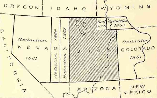
Political History and Area The Territory of Utah was organized September 9, 1850, its area being a part of that acquired from Mexico by the United States in 1848. As originally organized it extended from the summit of the Rocky Mountains in central Colorado westward to the east boundary of California, including all the territory between the parallels of 37° and 12° north latitude. These limits are thus defined in the act creating the Territory: All that part of the territory of the United States included within the following limits, to wit: Bounded on the west by the State of California, on the north by the Territory of Oregon, and on the east by the summit of the Rocky Mountains, and on the south by the thirty-seventh parallel of north latitude, be, and the same is hereby, created into a temporary government, by the name of the Territory of Utah. The organization of Colorado Territory, in 1801, reduced it on the east to its present eastern boundary, and the formation of the Territory of Nevada, in the same year, reduced it on the west to the meridian of 39° west of Washington. The enabling act of the State of Nevada, passed in 1861, moved the west boundary of Utah a degree farther east, placing it upon the meridian of 38°, and upon the admission of Nevada as a State, in 1866, Utah was still further diminished and Nevada increased, the eastern boundary of the latter being placed upon the meridian of 37° west of Washington. Meantime, in 1863, the northeast corner of the State was cut oil' and added to the Territory of Idaho, and in 1866 a square degree in the northeast was added to the Territory of Wyoming, thus reducing Utah to its present dimensions. On January 1, 1896, it was admitted as a State, its boundaries being the same as those of the Territory of Utah, as follows:
Commencing at the intersection of the forty-first parallel of north latitude with the thirty-second meridian west of Washington; thence south on this meridian to the parallel of 37° north latitude; west on this parallel to the thirty-seventh meridian west of Washington; north on this meridian to the parallel of 42° north latitude; east on this parallel to the meridian of 34° west of Washington; thence south to the forty-first parallel of latitude, and east on this parallel to the place of beginning. The area of the State is 84,970 square miles, of which it is estimated that 2,780 square miles are water surface, including Great Salt, Utah, and other lakes, and 82,190 square miles are land surface. Exploration From a very early time this region was traversed by Spanish caravans, traveling from Santa Fe, New Mexico, to Los Angeles, California. The old Spanish trail, which these caravans followed, entered
Utah on the east near Dolores River, crossed the Grand near the Sierra La Sal, and the Green at the present crossing of the Rio Grande Western Railway. It reached the valley of Sevier River near its bend, and turning south followed its valley to the head and down the Virgin to a point near its mouth, whence it turned westward, running out of the State near its southwest corner. This traffic, which at one time was great, left, however, no trace behind in the form of a settlement, and it was not until the hegira of the Mormons from the Mississippi Valley in 1847 that the present State of Utah received an; permanent inhabitants. The earliest recorded exploration of any part of Utah was a journal by two Franciscan fathers, Escalante and Dominguez, from Santa Fe, New Mexico, to the shores of Great Salt Lake, in 1776-77. So far i can be learned, their route followed in the main that of the old Spanish trail, and it is not at all improbable that they were the pioneers laying out the western part of this route to Southern California far as known, they were the first white men to visit the eastern pa of the Great Basin of Utah. This journey was not, however, fruitful in geographical discovery, excepting the fact that it may have determined the route of travel between the Spanish settlements of New Mexico and those of California. Between 1832 and 1836 Capt. B. L. E. Bonneville, of the United States Army, while on leave of absence, engaged in the fur trade in the West, and coupled with it a certain amount of exploration. He traveled extensively over the northeastern part of Utah, including the area drained by Bear River and its tributaries, and sent a branch expedition, under Captain Walker, to Great Salt Lake, down Humboldt River, and across the Sierra Nevada to California, returning by the route of the Spanish trail. No maps were prepared, and the only information derived from these explorations is contained in Washington Irving's narrative, which is very scanty and often erroneous. The real exploration of Utah began in 1842, when Capt. J. C. Fremont, with an army expedition, entering the region via Bear River, explored Great Salt Lake and the adjacent region. Upon his return from California in the following year he entered the Territory again, on the south, via Virgin River and the Sevier, reaching Utah Lake, and thence proceeded northeastward down Uinta River. Subsequent expeditions under army auspices, notably those of the Pacific Railroad explorations, Captain Stansbury's survey of Great Salt Lake, and Captain Simpson's explorations, made the main features of the Territory well known. Green and Colorado rivers, which flow mainly within this State, were explored by a daring boat journey undertaken and carried through by Maj. J. W. Powell in 1869, and in the course of this exploration the greater features of the plateau region traversed by the rivers were delineated and their structure was explained. The northern portion of the State, including the area of Great Salt Lake, was mapped by the United States Geological Survey of the fortieth parallel, in or about 1870, on a scale of 4 miles to an inch. Between 1873 and 1878 nearly all of the Territory was surveyed on a scale of 4 miles to an inch by the United States Geological Survey of the Rocky Mountain region, under Maj. J. W. Powell, and the resulting maps show the topographic features of the State in considerable detail. Since 1850 most of the level portions of the State have been subdivided by the General Land Office, and plats have been made of the surveyed townships. From these, with the maps of the survey of the fortieth parallel and of the Rocky Mountain region, the existing maps of Utah have been compiled. The atlas sheets referred to in the Gazetteer are published by the United States Geological Survey, the data borne upon them having been derived mainly from the work of the two organizations last mentioned. Settlement Utah was first settled by Mormons. Driven from their homes in Illinois, under the leadership of Brigham Young they made their way across the prairies, plains, and deserts to the valley of Great Salt Lake, then as remote a region as could be found on earth. This migration numbered many thousands. Its advance guard reached the valley of Great Salt Lake in 1847, and was followed during that and the years immediately succeeding by vast numbers of saints, so that, in 1850, the census report showed a population of 11,380; in 1860 this had increased to 40,273; in 1870, to 86,786; in 1880, to 143,963, and in 1890 it was 207,905. The growth of Utah in population has throughout been steady and rapid. It has, in the main, been a solid growth, dependent principally upon the development of its agricultural resources, and to some extent upon manufactures. Although many successful mines have been discovered and are in operation, the State has never had a great mining boom which has broken up its stable conditions. A B C D E F G H I J K L M N O P Q R S T U V W Y Z
Source: Bulletin of the United States, Utah, Geological Survey, by Henry Gannett, Government Printing Office, 1900.
|
||

Copyright August @2011 - 2024
AHGP The American History and Genealogy Project.
Enjoy the work of our webmasters, provide a link, do not copy their work